Bing Maps PCF Control
Bing Maps PCF Control
Overview
This PCF control allows you to display information for a view that contains latitude and longitude information within Bing Maps. The Info Box for each pushpin that is created on the map also gives you the ability to open the selected record.

Additional Features
- Map will default to a bounding box defined by the location data being shown.
- Will work with dataset that are 5k+ in size.
Installation Usage
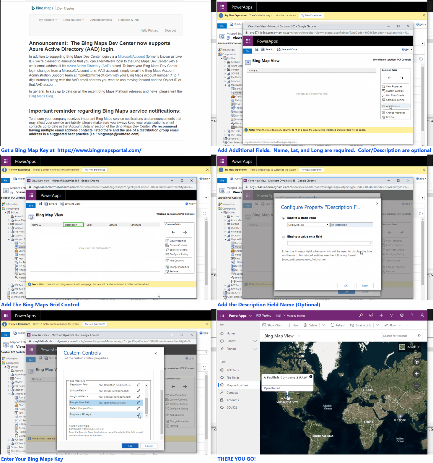
After you install the solution into your system create a new view and add the custom control to the view. Ensure you add the required fields to the view and any filter you want. After you create the view Publish the customizations and navigate to the new view. The video below provides additional details.

Download
The latest release is always available here.
Hello,
ReplyDeletei download the managed solution but how do i use this i dont see any option to user this control. do you have any kind of documentation how to use it ??
Thank you
Reashadali,
ReplyDeleteI have updated the article to include a video on how to create a new view which utilizes the control. Let me know if you have any other questions.
Thanks,
Rick
Hello. I have some problems. I can't install this into my solution. I got this error: The solution file is invalid. The compressed file must contain the following files at its root: solution.xml, customizations.xml, and [Content_Types].xml. Customization files exported from previous versions of Microsoft Dynamics 365 are not supported
ReplyDeleteWorking very well for accounts, but for "leads" it has a blue circle spinning, any idea what might be wrong ?
ReplyDeleteHi Richard,
ReplyDeleteI've downloaded your managed solution and I think it's amazing! I've installed it and used it in my environment. It worked perfectly Unfortunately I'm having issue working with datasets bigger than 2k+ records (on account entity) the map keeps loading without success. Do you have any suggestion on why could this be and how to solve the issue? I'm using a Dev/Test BingMaps api key as suggested.
Thank you in advance,
Mariagiovanna
Hi Richard,
ReplyDeleteI want to show more then one entity on the map (Customer and Owning team location). Is it possible to do so? Also, I want to change pushpin from circle to better pushpin image. Any possibility.
buy twitch followers During the summer months, there are a lot of great activities to be enjoyed. While at home or on vacation, there are several great lawn games that are quick to set up and easy to enjoy. From boules to quoits, there are ones that can be played by people of all ages.
ReplyDeleteRight now, Bing is presently attached with Yahoo for second in the internet searcher portion of the overall industry. Interestingly, Microsoft will actually want to say they are number 2. https://onohosting.com/
ReplyDeleteBing is right now attached with Yahoo for second in the internet searcher piece of the pie. Interestingly, https://onohosting.com/
ReplyDeletehttps://www.buyyoutubesubscribers.in/2021/10/30/does-youtube-pay-views/ Do you want to create and share videos for YouTube? If so then great! You've made an awesome decision!
ReplyDeleteHi Richard,
ReplyDeletethis PCF Control does exactly what I am looking for and it works great. However, no license information exists in GitHub. What is allowed and what is not with this control?
Hello i have a question , in the Descriptions1,2,3 i only can put a field of dataverse or there are some way that i can put a simple string too? thank you in advance.
ReplyDelete